Another trip out to Joshua Tree National Park last weekend, this time for a little bouldering and mountain biking out at Geology Tour Road.
On the road…driving through Banning Pass near Palm Springs.
I’ve been on Geology Tour Road quite a few times, but had not bouldered or mountain biked in that area for probably 15 years. Arrived at the West Entrance at about 7:20 a.m., and within half an hour was deep in the middle of nowhere on one of my favorite dirt roads. By the time I got out of the car to scope out the boulders, I could already tell it was going to be a hot one.

Looking out into Pleasant Valley from Geology Tour Road.

Young Joshua Trees and boulders near about 5 miles down Geology Tour Road.

Easy, juggy crack. I actually remember climbing this problem ~15 years ago. Quite fun, so I did it multiple times.

Little slabby arete that I thought was going to be lame…turned out to be much more difficult than it looked with some sparse, loose feet.
With the bouldering warmup done, and starting to feel the heat, I continued south down Geology Tour Road and parked in the Squaw Tank pullout. This is the last good place to park before the one-way loop portion of Geology Tour Road starts (about 100 yards south of the pullout).
Years ago I had mountain biked the upper portion of Geology Tour Road as an out-and-back. It sticks out in my mind as possibly the most miserable time I ever had on a bike, as there was just SO MUCH SAND. I was hoping that the loop portion of the road would not be nearly as sandy, but had no real beta on it.
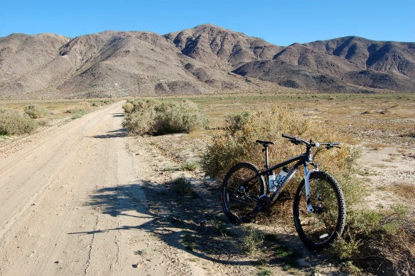
Crossing Pleasant Valley in Joshua Tree National Park.
The first ~1 mile of the loop was very sandy and kind of miserable in spots. It was downhill, but for the most part I had to ride slow because of the deep sand–in fact there were spots where I was going downhill but had to peddle hard just to maintain forward momentum. There were several spots where I just gave up and walked it.
That said, it was a nice ride going east along the base of the Hexie Mountains. Once the road turned south and crossed Pleasant Valley, the peddling got easier but there was still some sand in spots. It was nice to be out in the middle of the valley, early in the morning, all alone. Well, not completely alone. As I peddled across, I spooked a flock of several hundred sparrows who were hunkered down in the low grass “meadow” of Pleasant Valley. It was quite a sight, to be right in the middle of all those birds.
The road then turned to the southwest for a mild climb up along the base of the Little San Bernardino Mountains. Just before the road turned north back towards Squaw Tank, I came to this Wilderness boundary right next to the road at at the start of a hiking trail (the “Pushwalla Corridor”).
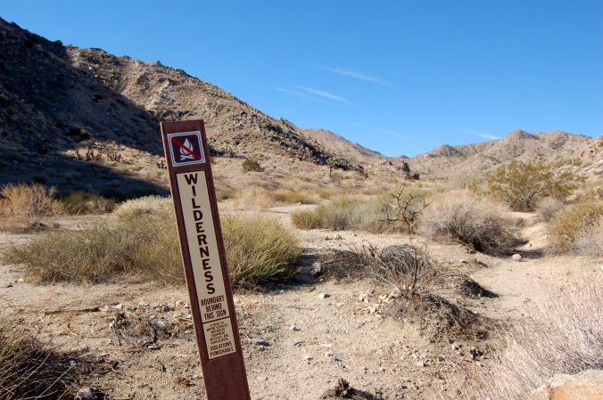
I later did some research online and it appears that this is the aptly named Joshua Tree Wilderness Area, but I could not find a map that shows the boundary coming this close to the road…?
At this point the heat was starting to get to me, so I took a little break and drank a bunch of water, then pushed the last 1.5 miles or so back to the car.
 The last half to three quarters of a mile back to the car featured a lot of annoying sand, and I spent most of the time trying to read the road and not enjoying the scenery. But it was absolutely gorgeous out there.
When I got back to my car, a large SUV drove by–the first other sign of human life I had seen on Geology Tour Road that morning. By the time I had made it back to the pavement, about a dozen four wheel drive vehicles had sped past me. On Geology Tour Road, it pays to get an early start…
The total trip was about 6.2 miles with about 550 feet of elevation gain. It was more strenuous than I expected, because of all that damn sand. An excellent morning of bouldering and mountain biking in one of the most beautiful places on earth, but when it was over, I needed this place: